
Why you should do the Routeburn
- Simone
- Jan 21, 2021
- 5 min read
I read recently that the Routeburn track is considered one of the top ten most scenic hikes in the world. This was before I had tackled it so I thought, meh, I've done the Milford Track, it can't be better than that...

Let me just say, I like being proven wrong.
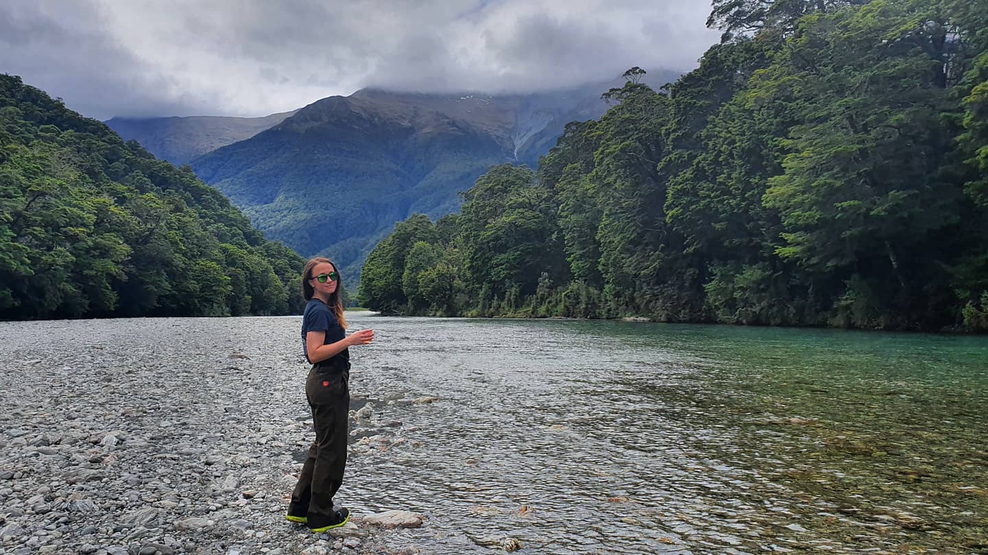
Three days before I departed Otago I decided to run part of the Routeburn. Unlike Milford, Keplar or Hollyford you can start walking (running) from the Glenorchy side as you follow the 37km track to the divide into the Fiordlands. In typical Simone fashion I made this decision the night before because I checked the weather and saw that it was a clear day. I CANNOT STRESS ENOUGH THAT CLEAR WEATHER IS KEY TO A GOOD TIME OUT THERE. The Fiordlands are a fickle beast and rain and cloud will ruin your day very easily if you intend to get clear blue pools and stunning views over the vistas.

The drive from Queenstown to the start of the track takes about 1.5 hours, I say this as tourists are abundant on these roads and you will inevitably be stuck behind someone at some point who will make you want to tear your hair out. From the Glenorchy side you are spoilt for choice in terms of walks, the Dart track, Reese Valley, Paradise and multiple other hikes spawn from this area. The Routeburn beginning alone has about 5 different tracks branching off it in the first 7 kms that can often become confusing, signs are definitely a "read carefully" job.

With only one day I planned to just get about halfway and turn around. My goal was Harris saddle which gave me enough time to turn around and swim on the way back. All up I believe I did around 30km however my watch had a moment and decided to record in 2 halves and miss a chunk so you'll have to take my word for it.

The first bit of the track is a bit of a highway, there are many people wandering the first few kilometres to the blue pools to swim in. Often people camp at the Routeburn Flats hut as well as those completing the "great walk". It's nice to see so many day walkers out there. The first 7km to the hut is pretty easy. There is elevation however it's not too technical and is only about 300m up. There are so many spots to stop along this part that you end up just going "ooo" and "aaah" and use way to much phone battery taking a thousand pictures.
I hate to say it but within the first 3kms I knew the article writers saying it was the most scenic were correct. You run through a stunning Beech forest with pockets of ferns and waterfalls. It often doesn't feel real, like nothing could ever be this beautiful.

The last section just before the first hut is just glacial pools and rivers. I don't think photos do these places justice, the water is so pristine, the only thing that definitely reminds you of reality is the fact the pools are FREEZING.

From Routeburn Flat hut turn off the "real fun" begins. The elevation profile changes and you ascend pretty steeply to the Routeburn Falls hut. I walked most of this. There is an amazing cutaway from a landslide that gives a sweeping view up the North Branch of the Routeburn. There are some swing bridges and peeks out to the view often as well as little waterfalls along the side. I imagine in heavy rain the track is difficult to maneuver with a pack.
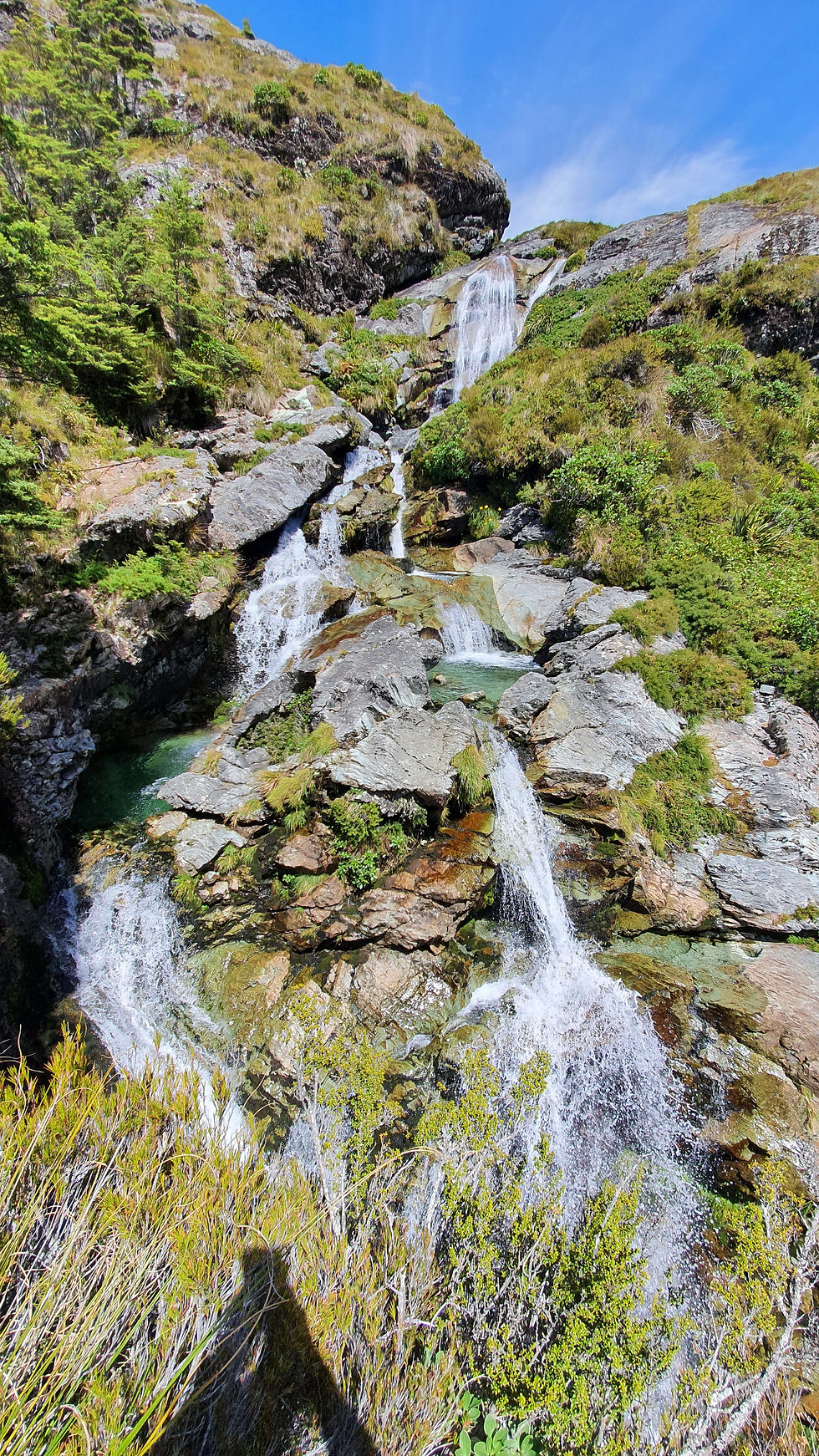
The Routeburn Falls Hut has to be one of the most beautiful huts I have ever been too. Ignoring the Guided huts monstrosity that is behind (with power and showers, IT'S A WILDERNESS WALK GODDAMMIT) hilariously the Doc hut has the best views looking all down the Routeburn Valley. Behind the hut is a selection of falls that drop into clear pools then rise into the valley above. I just spent most of my time with my phone out taking photos over every rise.
Beyond the hut you continue walking towards the saddle. This part of the walk is very exposed and already being overheated from the walk up I was certainly feeling the heat being in an exposed area. This sections boasts beautiful daisies and other summer wildflowers in January.

I loved this section the most to run, it's pretty flat till you get to the lake and the surrounding mountain ranges are jagged and gnarly, they have this Lord of the Rings feel which I always find in the Fiordlands.
Again a clear and nice day is crucial because a fierce wind would make this unbearable.

I stopped at Lake Harris and had lunch, originally I was planning to eat at Harris Saddle but I was beat and needed some food. There is a little trig track down to the lake and sitting on the edge by myself enjoying the brooks and streams gurgling away next to me was pretty calming, it felt like one of those audio clips to help you relax and stop being anxious (note, this did not calm me about moving countries over the next week but it did make me feel a bit better).
After snacks I made the last 3 kms up to Harris saddle. This is a cool path but lots of uneven steps. I was glad I wore my trail runners as it was a bit treacherous moving quickly and I almost slipped a dozen times on uneven rocks.

Harris Saddle is the turn off for Conical Hill walk off the main track. I thought when I arrived that I actually wasn't there yet. Just over the hill you get a full view of the Hollyford Valley and you can see the divide road from this point (again clear day). There are two emergency shelters there. The guided walks one, nice well kitted out and very user friendly, Doc, sparce and has an avalanche pokey stick. Oh well you get what you pay for and considering this walk is free for day hikers I guess that's fine.

I only wandered down an extra 400m to get these views of the mountains. I could have also walked up Conical Hill but I was tired and hot so I decided to head back. Mum and dad walked the Routeburn several years ago and said Conical Hill was great on a clear day and definitely worth the apparently 1.5 hour round detour. I guess I'll just never know.

I ran back most of the way, stopping to talk to a few hikers. It's a pretty easy return it just isn't the best in sun. I swam twice as I returned. I wanted a spot away from people so I ducked off a side suspension bridge and found a shaded section of the river to swim in. I also dipped in the big blue pool because why not! It certainly was a great end to a day (until I ran out of water in the last 4km!)
The Routeburn can be completed in many ways. I chose to run part of it as that was all I had time for. If you're walking it you need to allow most of the day if you want to reach the saddle comfortably. There are camping options on Doc and you can organise key swaps on facebook if you want to try and get a cheap alternative to relocating your car if you're doing the whole lot. The Doc bookings for huts open in October generally and cost about $200. You have to factor in getting to and from the parking lots which can become costly particularly if you have multiple people or children.
I like the idea of walking the Glenorchy side as a day walk, it is picturesque with many options to turn around having already seen something ridiculously cool. It's also free which I think is great.
In terms of being "top ten in the world" I don't think I've traveled enough to make that claim. However it ranks very highly as one of the best days I've had trail running and I took enough photos to say it was worth every minute.


Comments